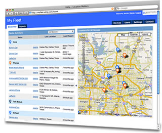
Geomoto: in summary
Geomoto is designed to elevate asset management for businesses using the power of GIS mapping. Perfect for industries like logistics and urban planning, it offers dynamic visualization, real-time data analytics, and seamless integration, ensuring a comprehensive edge over competitors.
What are the main features of Geomoto?
Dynamic GIS Mapping
Unleash the potential of Geographic Information Systems with Geomoto's dynamic mapping capabilities. This feature allows users to effectively visualize data in comprehensive geographical layouts.
- Interactive maps for detailed data exploration
- Customizable layers for tailored insights
- Real-time updates for accurate geographical representation
Real-Time Data Analytics
Transform raw data into actionable insights with Geomoto's real-time analytics. Stay ahead of industry demands by making informed decisions based on the latest available data.
- Instant processing for swift decision-making
- Dashboard with critical data points
- Predictive analytics for future trend forecasting
Seamless Integration
Enhance your existing workflows by integrating Geomoto with your current systems. This ensures data consistency and optimizes operational efficiency across platforms.
- Compatible with major enterprise systems
- Simple API for hassle-free integrations
- Synchronize data across multiple platforms

Geomoto: its rates
standard Rate On demand |
|---|
Clients alternatives to Geomoto
Appvizer Community Reviews (0)
No reviews, be the first to submit yours.


